Paleogeology
Paleogeology, Paleoclimate, in relation to Evolution of Life on Earth
biostratigraphy
Despite differences in sedimentary environment, and hence appearance, rock formations with similar fossil species can be assumed to be roughly contemporaneous. The more rapidly a species evolved, the narrower the geological time frame in which it was fossilized and the more useful it will be for age correlation. Some index fossils are particularly useful in biostratigraphy by virtue of rapid evolution, abundant and widespread occurrence relatively unaffected by environment, and easy identifiability.
Stages are defined by the group of strata containing the same major fossil assemblages, while zones or biozones are strata displaying an overlapping range of fossils. | 0 Guide-Glossary
paleomagnetism
Paleomagnetic studies employ the phenomenon in which magnetic minerals, such as magnetite, record the Earth's magnetic field at the time of solidification of magma or lava (Curie temperature). [image computer simulation of Earth's magnetic field] This magnetic record of prior magnetic orientation is termed thermal remnant magnetism (TRM) for igneous and metamorphic rocks, and detrital (depositional) remnant magnetism (DRM) for sedimentary rocks in which individual grains of magnetic minerals align with the magnetic field during their deposition as sediments. Chemical remnant magnetism (CRM) can be detected in some rocks as magnetic grains are deposited from circulating solutions.
Paleomagnetism has been employed to:
● map sea floor spreading as basaltic oceanic crust spreads from its line of formation along mid-ocean ridges, providing strong empirical support for theories regarding plate tectonics as a mechanism for continental drift [diagram, magnetic stripes, ridges, ridges 2, ridges 3]
● map polar wandering
● determine past global positions of ancient rock formations or terranes (when combined with radiometric determination of the age of a rock formation)
● constraining possible ages for rocks and for geologic processes
● reconstructions of deformational histories of segments of the crust.
: e-Book Magnetic Domains to Geologic Terranes (pdf) : e-Book Lectures in Paleomagnetism (html or pdf) : paleomagnetism analyses USGS : The Geodynamo :
news and articles : Earth's Inconstant Magnetic Field (NASA) : Earth Magnetic Field Reversal : Earth's Magnetic Field Is Fading & Earth's Core Spins Faster Than Surface, Study Confirms & Magnetic Field Weakening in Stages, Old Ships' Logs Suggest & Why Does Earth's Magnetic Field Flip? & North Magnetic Pole Is Shifting Rapidly Toward Russia & "Magnetic Map" Found to Guide Animal Migration & Magnetic Beaks Help Birds Navigate, Study Says & Migrating Birds Reset "Compasses" at Sunset, Study Says & Bats Use Magnetic "Compasses" to Navigate, Study Says & Lobsters Navigate by Magnetism, Study Says & Space Dust Flooding Our Solar System & New Solar Telescope Would Focus on Sunspots, Storms National Geographic :
Labels: chemical, deformation, detrital, dynamic metamorphic zones, igneous rock, magnetic, magnetite, paleomagnetism, plate tectonics, sedimentary, terranes, thermal remnant magnetism
| 0 Guide-Glossaryradiometric dating

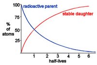
Each radioactive isotope (atoms of the same element differing in neutron number) has its own unique half-life, which is the time required for half of the parent radioactive element to decay to a daughter product. Radioactive decay occurs at a constant exponential or geometric rate, so half of parents will decay to daughters (1:1) in one half life and one half of the remaining parents will decay in the next half life (1:3).
Table Radiometric Dating
Geologists estimate the length of time over which decay has occurred by measuring the ratio of radioactive parent element and stable daughter elements. Radioactive elements tend to become concentrated in the residual melt during the crystallization of igneous rocks, so traces of a radioactive mineral in an igneous rock will 'set the clock' at the time of cooling/solidification.
K-40 decays to Ar-40 (a gas trapped in the rock) with a half-life of 1.25 billion yrs and is found in:
amphiboles
glauconite (greensand, rare)
muscovite
potassium feldspar (orthoclase)
U-235 decays to Pb-207 with a half-life of 704 million years, and the much more abundant U- 238 decays to Pb-206 with a half-life of 4.47 billion years. Uranium can be found in:
apatite
monazite
sphene
urananite
zircon
Sedimentary rocks comprise grains with 'clocks' set to the time of cooling of the parent igneous rocks. So radiometric dating of sedimentary rocks is meaningless concerning date of formation unless the sediment contains unusual minerals such as glauconite that formed on the seafloor as the rock was cemented.
The spontaneous fission of uranium creates fission tracks in the crystal lattice of minerals that contain U. Fission tracks can be visualized and counted in micas, tektites, and natural volcanic glass.
◘ Hadean ◘ Archaean ◘ Archaean supercontinents ◘ Proterozoic ◘ Phanerozoic ◘ geologic provinces ◘ mantle plumes
USGS Geologic Time: Radiometric Time Scale
tags [Paleogeology] [radiometric dating] [fission tracks] [geological dating]
Labels: fission tracks, half-life, isotope, radiometric dating
| 0 Guide-Glossaryseismology
Seismic vibrations travel as P-waves, S-waves, and surface waves (Rayleigh and Love surface waves). Structure determination is based on the differential transmission of seismic vibration through materials of different density and state (molten, solid).
P-waves, or pressure waves, or primary waves travel the fastest and propagate as alternating vertical compressions and contractions. P-waves, like sound waves, propagate through a liquid medium, so can travel through the Earth's molten core. S-waves, or shear waves, or secondary waves, are slower than P-waves and arrive later at a seismogram later than P-waves. Unlike P-waves, S-waves travel only through solid rock and cannot reach a seismograph on the opposite side of the planet from a seismic event (shadow), providing evidence for Earth's molten core. Surface waves result when P- and S-waves interact at the surface.
Rather than wait for natural seismic events, geologists employ controlled source seismology (small explosions) and receiver functions to map geological features such as rock types and discontinuities, geologic traps, faults, buried craters, salt domes. Receiver functions show seismic energy that has been converted to shear waves from direct P-waves at discontinuities within the earth.
NG interactive earthquakes :
Labels: controlled source seismology, cryoseic quakes, discontinuity, P-waves, receiver functions, S-waves, seismology, surface waves, tectonic quakes
| 0 Guide-Glossary


