Paleogeology

Paleogeology, Paleoclimate, in relation to Evolution of Life on Earth

breccia

basaltic breccia with epidote groundmass.Breccias are clastic, sedimentary rocks comprising angular fragments from a previous rock structure that have been cemented in a matrix.
image: basalt breccia with epidote groundmass, courtesy of Siim Sepp

Classification of breccias relates to their constituents, mode of occurrence, constituent fragment size, types of clasts, and source of clasts.

Many breccias comprise consolidated talus or scree material, and are made up of accumulations of rock fragments that have fallen down steep hill slopes or cliffs. Breccia are often found above uncomformities, and so are associated with conglomerate, arkose and sandstone. (Conglomerates have rounded fragments.) Other breccias are produced by the fragmentation of rocks during faulting (tectonic or monomictic breccia), or during volcanic eruptions (eruption breccia, vent breccia), or collapses such as in karst areas, or form upon meteorite impacts (often in breccia dikes). Monomictic breccias result from rock deformation by shearing and granulation (cataclasis) in the process of tectonism or dislocation metamorphism, while impact breccias have been called "monomictic movement breccias".

[images: hand-specimens: breccia, 2, 3, 4, chert breccia; breccia in copper, 2; impact breccia; thin-sections : volcanic breccia; fault breccia in the Antietam Formation; Breccia Pernice marble, Breccia Aurora marble; formations: cliffs of volcanic breccias formed by lahars; Wawa xenolithic breccia, Wawa Heterolithic Breccia; Ries impact structure, Iggenhausen quarry, monomictic movement breccia, close-up; Azuara impact structure close-up; grit brecciation and mortar texture, Rubielos de la Cérida impact basin, and heavily brecciated and polished scour surface; strongly brecciated chert nodule, Malmian limestone, Ries impact structure; breccia dikes in Liassic limestones south of Belchite (Deutsche)]

Labels: , , , , , , ,

rocks

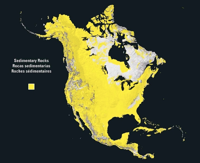
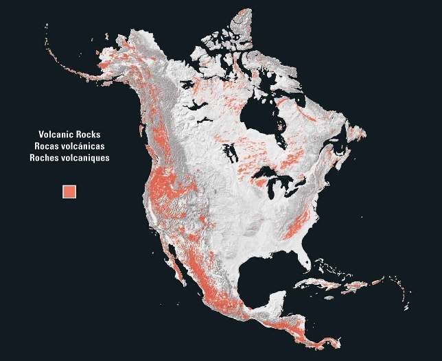
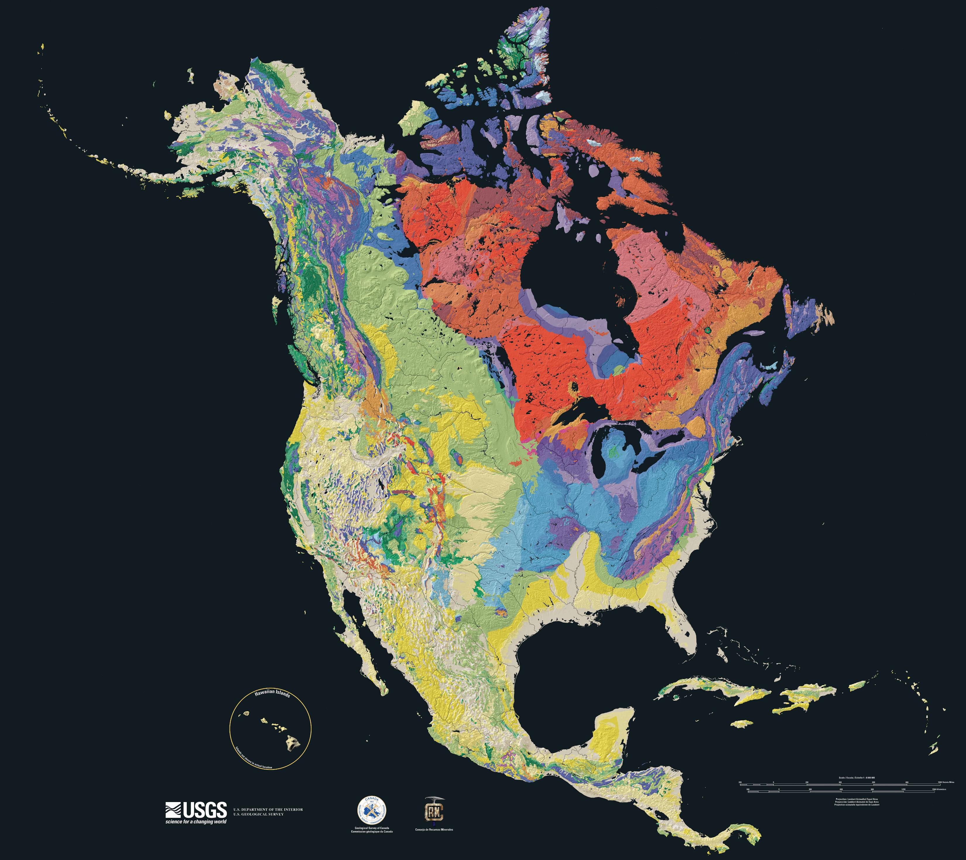
Maps of North American rock types : rock types - metamorphic, plutonic, sedimentary, volcanic; tapestry of time and terrain, terrain ▪ North American Craton

Petrology ◘ basalt ◘ breccia ◘ felsic (sial) ◘ gabbro ◘ granite ▪ greenstone belts ◘ hornfels ◘ igneous rocks ◘ lava ◘ mafic (sima) ◘ magma ◘ metamorphic rocks ◘ peridotite ▪ porphyry ▪ plutonic ◘ rocks ◘ sedimentary rocks ▪ texture ▪ xenoliths ▪

Mineralogy ◘ crystallization ▪ phenocryst

Tables Geology Section  Elemental Composition of Crust  Flood Basalts and Stratigraphic Boundaries  Minerals & Rocks: Carbonates  Minerals & Rocks: Evaporates, Sulphates  Minerals & Rocks: Metamorphic  Minerals & Rocks: Oxides  Radiometric Dating  Volcanoes  Weathering of Minerals 

images : Rock gallery :

Labels: , , , , ,

| 0 Guide-Glossary

sedimentary rocks

Archean sedimentary rocks are mostly coarse and poorly sorted sandstones and conglomerates.

Labels: , , ,

| 0 Guide-Glossary

paleomagnetism

Paleomagnetism is used to determine Earth's ancient magnetic orientation and the orientation of rock bodies relative to the magnetic poles at the time of rock formation.

Paleomagnetic studies employ the phenomenon in which magnetic minerals, such as magnetite, record the Earth's magnetic field at the time of solidification of magma or lava (Curie temperature). [image computer simulation of Earth's magnetic field] This magnetic record of prior magnetic orientation is termed thermal remnant magnetism (TRM) for igneous and metamorphic rocks, and detrital (depositional) remnant magnetism (DRM) for sedimentary rocks in which individual grains of magnetic minerals align with the magnetic field during their deposition as sediments. Chemical remnant magnetism (CRM) can be detected in some rocks as magnetic grains are deposited from circulating solutions.

Paleomagnetism has been employed to:
● map sea floor spreading as basaltic oceanic crust spreads from its line of formation along mid-ocean ridges, providing strong empirical support for theories regarding plate tectonics as a mechanism for continental drift [diagram, magnetic stripes, ridges, ridges 2, ridges 3]
● map polar wandering
● determine past global positions of ancient rock formations or terranes (when combined with radiometric determination of the age of a rock formation)
● constraining possible ages for rocks and for geologic processes
● reconstructions of deformational histories of segments of the crust.

: e-Book Magnetic Domains to Geologic Terranes (pdf) : e-Book Lectures in Paleomagnetism (html or pdf) : paleomagnetism analyses USGS : The Geodynamo :

news and articles : Earth's Inconstant Magnetic Field (NASA) : Earth Magnetic Field Reversal : Earth's Magnetic Field Is Fading & Earth's Core Spins Faster Than Surface, Study Confirms & Magnetic Field Weakening in Stages, Old Ships' Logs Suggest & Why Does Earth's Magnetic Field Flip? & North Magnetic Pole Is Shifting Rapidly Toward Russia & "Magnetic Map" Found to Guide Animal Migration & Magnetic Beaks Help Birds Navigate, Study Says & Migrating Birds Reset "Compasses" at Sunset, Study Says & Bats Use Magnetic "Compasses" to Navigate, Study Says & Lobsters Navigate by Magnetism, Study Says & Space Dust Flooding Our Solar System & New Solar Telescope Would Focus on Sunspots, Storms National Geographic :

Labels: , , , , , , , , , , ,

| 0 Guide-Glossary

. . . stratifying since 10/06/06