Paleogeology

Paleogeology, Paleoclimate, in relation to Evolution of Life on Earth

Paleogeology: Geological Time

 Geological Time : Hadean
..............................Archean .....................Archaean supercontinents
..............................Proterozoic
..............................Phanerozoic

Labels: , , , ,

| 0 Guide-Glossary

Archaean

The Archaean, or Archean Eon extends from 3.8 billion years ago until 2.5 billion years ago.

The Eon was formerly called the Archaeozoic, and is subdivided into Eoarchean (3.8-3.6 Ga), Paleoarchean (3.6-3.2 Ga), Mesoarchean (3.2-2.8 Ga), and Neoarchean (2.8-2.5 Ga) Eras or into early (to 3.3Ga), middle (to 2.9 Ga), and late Archaean.

Life arose about 4 billion years ago, at the close of the Hadean Eon, and Cyanobacteria comprise the earliest known microfossils. The Cyanobacteria built large stromatolite reefs and dominated life for more than 2 billion years (~3.5 Ga to ~1 Ga). The atmosphere remained reducing for much of the Achaean, though Cyanobacteria began to generate oxygen after approximately 2.8 to 2.7 Ga.

Earth's heat flux during the Archaean was much higher than current levels: early in the Archaean the flux was almost triple current levels, while heat flows fell to twice current levels by the end of the Archaean. As a result of the high heat flow, the Earth had numerous hot spots, very active volcanoes, and rift valleys. Earth continued to experience bombardment by extrasolar debris plus the late heavy bombardment until 3.5 Ga. The majority of Archean rocks still in existence are crystalline cratonic remnants, which include unusual lavas (e.g., komatiite), intrusive igneous rocks such as great melt sheets, and voluminous plutonic masses of granite, diorite, ultramafic to mafic layered intrusions, anorthosites and monzonites known as sanukitoids.

Scientists continue to actively debate the contribution of plate tectonic activity in the formation of Archaean crustal configurations. Large continents did not form until late in the Archean, and the felsic protocontinents probably formed at hotspots over mantle plumes rather than at subduction zones. Protocontinents probably resulted from:
● igneous differentiation of mafic rocks to produce intermediate and felsic rocks
● mafic magma melting of more felsic rocks
● granitization of intermediate rocks
● partial melting of mafic rock
● metamorphic alteration of felsic sedimentary rocks.
Much continental material may have been lost if rocks were not sufficiently buoyant or were consumed at energetic subduction zones.[2]

The oldest rocks so far discovered on Earth are:
1) Jack Hills, Western Australia, a 4.4 Ga detrital zircon (sample W74) in the Jack Hills metaconglomerate, Eranondoo Hill. More at Earliest Piece of Earth [news article]
2) The Acasta Gneisses near Canada’s Great Slave Lake (4.03 Ga)
3) The Isua Supracrustal rocks of West Greenland (3.7 to 3.8 Ga)
4) Northern Michigan (3.5-3.7 Ga)
5) Swaziland (3.4-3.5 Ga)

approximate ages of earliest continent (Ur) and supercontinents (Vaalbara, Kenorland)Archaean Supercontinents and continents:
Vaalbara is Earth's theorized first supercontinent, which, according to radiometric data, existed by 3.3 billion years ago (3.3 Ga) and possibly even as far back as 3.6 Ga. Geochronological and palaeomagnetic evidence suggests Valbaara began to break up ~2.8 Ga.

Ur was the first known continent, which probably formed 3 billion years ago in the early Archean Eon.

By about 2.7 Ga, Neoarchean sanukitoid cratons plus new continental crust accreted to form another of Earth's earliest supercontinents, Kenorland.

Two contrasting mechanisms have been proposed for Archean tectonics: “vertical tectonism” and “horizontal tectonism”. Vertical tectonism is attributed to density inversions inherent between denser volcanic sequences (greenstones) and underlying less dense sialic material (granitoids), which result in the buoyant rising of granitoids (diapirism) and sinking of greenstones (sagduction). Horizontal tectonism in the Archean is assumed to be similar (though probably not identical) to present-day plate tectonics, so is characterized by regional scale horizontal motion (drift) and resulting interactions of plates or microplates. Vertical tectonism can lead to local horizontal movement, and horizontal tectonism commonly results in vertical movement, as in collisional zones. However, regional scale horizontal displacements and regional scale strike-slip faults (or shear zones) cannot be explained by vertical tectonism and most likely results from horizontal tectonism. Vertical and horizontal tectonism were not necessarily mutually exclusive.

While Archean geologists now accept that processes similar to present-day plate tectonics existed in some form in the Archean, particularly in the Neoarchean, studies continue to document evidence for vertical tectonism. Recognition of synchronous vertical and horizontal tectonism proves challenging because it is often difficult to differentiate structures formed by synchronous processes from those formed by one of the two processes followed by the other. It has been suggested that the granite-greenstone patterns in the Dharwar craton in India resulted from the interplay of diapirism and bulk horizontal inhomogeneous contraction. It has also been suggested that the kinematics of a high strain zone in the northwestern Superior craton resulted from synchronous horizontal and vertical tectonism. [Lin]

◙ subduction zone magmas ◙

Labels: , , , , , ,

| 0 Guide-Glossary

Archaean supercontinents

The Archaean, or Archean Eon extends from 3.8 billion years ago until 2.5 billion years ago.

(image at left – current approximate distribution of most Archean crustal rocks (the projection greatly exaggerates the area of polar landmasses – compare with image of location of cratons and platforms)

The Archean mantle was hotter than the Earth's current interior, resulting in heavy mantle convection and crustal turbulence. Archean Earth was very active tectonically, with higher rates of volcanic activity and plate boundary movement than is occurring today. Active tectonics during the Archean created numerous, mobile protocontinental landmasses that floated on the turbulent mantle. Toward the end of the Archean, the proto-continents began to coalesce, and by about 3.3 Ga the more tectonically stable supercontinent Vaalbara is hypothesized to have formed by accretion of smaller landmasses.

The oldest Archaean rocks so far discovered on Earth are:
1) The Isua Supracrustal rocks of West Greenland (3.7 to 3.8 Ga)
2) Northern Michigan (3.5-3.7 Ga)
3) Swaziland (3.4-3.5 Ga)
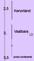
approximate ages of earliest continent (Ur) and supercontinents (Vaalbara, Kenorland)Archaean Eon:
70% of modern continental shields date from 3.0 to 2.5 billion years ago, which was the period of maximum continent formation. Most of the earliest rocks have been greatly altered through regional metamorphic processes, but later rocks (3.2-2.5 Ga) are mostly pillow-basalts that formed beneath the vast oceans. Archean sedimentary rocks are mostly coarse and poorly sorted sandstones and conglomerates.

The oldest fossilized signs of life date from the Archean – Cyanobacteria that created 3.45 Ga old stromatolite fossils found in the Apex Chert at Marble Bar, Western Australia. Microfossils from Swaziland (South Africa) have a similar age.[image]

Vaalbara is Earth's theorized first supercontinent, which, according to radiometric data, existed by 3.3 billion years ago (3.3 Ga) and possibly even as far back as 3.6 Ga. Evidence includes geochronological and palaeomagnetic studies between the two Archaean cratons (protocontinents) called the Kaapvaal craton (the Kaapvaal province of South Africa) and the Pilbara craton (the Pilbara province of Western Australia).

Further evidence is the structural sequence similarities of the greenstone belts and gneiss belts of the Kaapvaal and Pilbara cratons. These same Archaean greenstone belts are now spread out across the margins of the Superior craton of Canada and across the cratons of the former Gondwana and Laurasia continents. The subsequent drift paths of the Kaapvaal and Pilbara cratons after 2.8 Ga gives further evidence that they were once connected.

It is not certain when Vaalbara began to break up, but geochronological and palaeomagnetic evidence show that the two cratons had a rotational 30 degree latitudinal separation at 2.78 to 2.77 Ga, implying that they were no longer contiguous after ~2.8 Ga.

Ur was the first known continent, which probably formed 3 billion years ago in the early Archean Eon. Ur joined with the continents Nena and Atlantica about one billion years ago to form the supercontinent Rodinia. Ur survived for a long time, until it was torn apart when the supercontinent Pangaea broke apart about 208 million years ago into Laurasia and Gondwanaland. Ur now forms parts of Africa, Australia, India, and Madagascar. In the early period of its existence, it was probably the only continent on Earth, and is so considered by some to be a supercontinent, even though it was probably smaller than Australia is now.

By about 2.7 Ga, Neoarchean sanukitoid cratons plus new continental crust accreted to form another of Earth's earliest supercontinents, Kenorland, which comprised the Laurentia, Baltica, Australia, and Kalahari cratons. The Baltic/Fennoscandian Shield formed the core of Kenorland, with origins that trace back more than 3.1 Ga. The Yilgarn Craton (present-day Western Australia) contains 4.4 Ga detrital zircon elements.

Protracted tectonic magna plume rifting occurred between 2.48 to 2.10 Ga, contributing to the break-up of Kenorland during the Late Neoarchaean and early Paleoproterozoic Era (2.48 to 2.10 Ga) during the Siderian and Rhyacian periods. The rifting is manifested by mafic dykes and sedimentary rift-basins and rift-margins on many continents. On early Earth, this type of bimodal deep mantle plume rifting was common in Archaean and Neoarchaean crust and continent formation.

The geological time period remains conjectural at which Earth made the transition from deep-mantle-plume mechanism of continent formation to the current two-layer core-mantle plate tectonics convection mechanism that forms continents by subduction, convergence and accretion. However, with the findings of the earlier continent Ur and the ca. 3.1 Ga supercontinent Vaalbara, this transition period may have occurred much than the time of Kenorland.

Paleomagnetic studies indicate that Kenorland lay in low latitudes until the rifting breakup commenced around 2.48 Ga. Paleomagnetic evidence further indicates that at 2.45 Ga the Baltic/Fennoscandian Shield, astride the equator, was attached to Laurentia (the Canadian Shield), forming a unity with both the Kola and Karelia cratons, which began to drift apart ~2.45 Ga. By 2.4 Ga, the Kola craton was located at ~15 degrees latitude and the Karelia craton had drifted to ~30 degrees latitude. Paleomagnetic evidence indicates that at 2.45 Ga the Yilgarn craton (now the bulk of Western Australia) was not connected to Fennoscandia-Laurentia and was located at ~70 degrees latitude. This suggests that Kenorland was no longer a supercontinent by 2.45 Ga. By 2.4 Ga, an ocean separated the formerly joined Kola and Karelia cratons.

Based on the rift margin spatial arrangements of Laurentia, it is hypothesized that the Slave and Superior cratons were not part of the rifting supercontinent Kenorland, but may instead have been two different Neoarchaean landmasses (supercratons) located at opposite poles of a very large Kenorland. This speculation is based on the mechanics of how drifting assemblies of various constituent pieces should flow reasonably together toward the amalgamation of the new subsequent continent. The Slave and Superior cratons now constitute the NW and SE portions of the Canadian Shield, respectively.

The breakup of Kenorland was contemporary with the 60 million year long Huronian glaciation. The banded iron formations (BIF) show their greatest extent at this period, indicating massive increase in oxygen build-up (estimated 0.1% to 1% of atmosphere). Rising oxygen levels caused virtual disappearance of the greenhouse gas methane, which was oxidized into carbon dioxide and water. The simultaneous breakup of Kenorland increased continental rainfall, increasing erosion and further reducing the other greenhouse gas carbon dioxide. This reduction in greenhouse gases coupled with solar output still less than 85% its current levels precipitated a runaway Snowball Earth scenario, when average temperatures planet-wide plummeted to below freezing. Despite the anoxia indicated by the BIF, photosynthesis continued, stabilizing climates at new levels during the second part of the Proterozoic Era.

◙ subduction zone magmas ◙

More: GeoWhen Database : Tectospheric keels : 2004 time scale endorsed by the International Commission on Stratigraphy

Labels: , , , , , , , , , , , , , , ,

| 0 Guide-Glossary

sedimentary rocks

Archean sedimentary rocks are mostly coarse and poorly sorted sandstones and conglomerates.

Labels: , , ,

| 0 Guide-Glossary

Acasta Gneiss Complex

Cleaned exposures of the Acasta gneisses at their discovery site. Ancient tonalites (4.03 Ga) occur on left side of the picture, and are intruded by highly deformed younger granite sheets and mafic dykes. Courtesy of Natural Resources Canada The Acasta Gneiss Complex is located in Canada's northwestern Slave Province, NWT. (more images at Geomorphology, lithology, geological history of the Slave craton.)

Dating from the Hadean at least 4.03-4.055 Ga, is Earth's oldest known crustal rock outcrop. The complex comprises mostly Gray gneiss (granodioritic gneiss), White gneiss (tonalitic to granitic gneiss), foliated granite (3.6 Ga), and many aplite and basaltic intrusions.


The gneisses are embedded in a large Mesoarchean-Hadean basement complex, which lies beneath the west-central Slave craton. This craton is a complex containing ancient collisional orogenic structures and accreted fragments. Its rock formations comprise ancient crust, juvenile arcs, mature arcs, and intervening accretionary prism material. All tectonostratigraphic units are cut by strike-slip faults and later-emplaced granitic plutons, and many strata show evidence of late extensional collapse structures. Most rock types are derived from basaltic protoliths. The basement complex is overlain by Neoarchean supracrustal sequences has plutonic intrusions dating from 2.72-2.58 Ga. (Synvolcanic plutons date from 2.72-2.67 Ga and granitic batholiths date from 2.59-2.58 Ga (late-orogenic).)

Zircon geochronology has demonstrated that at least four magmatic or metamorphic events occurred in the Acasta Gneiss Complex: 4.0~3.95 Ga, 3.75 Ga, 3.6 Ga and 3.4 Ga. Zircon from a White gneiss has revealed an age of 4,203 +/- 28Myr, implying that granitic continental crust was more widespread than previously thought, and that it was reworked into Early Archean continental crust.[r]

Weathering of the Acasta Gneisses indicates that they have been exposed by erosion for a considerable time. In other areas, quartzite, banded iron formations, and volcanic rocks sit unconformably atop the gneisses.

The Archean gneisses were united at the core of the Slave protocontinent, at least 2.9 Ga. In the nucleus of the old continent, juxtaposed rocks sometimes differ by a billion years in age, probably indicating episodic volcanic eruptions, fed by broad plumes of rock ascending periodically from the deep mantle, rather than having resulted from gradual tectonic accretion of crust at plate boundaries. Such lava flows presumably gradually built up the continental nuclei as a part of mantle mafic-ultramafic and crustal acid magmatism.

The Archean rocks subsequently experienced uplift, possibly because of a hot mantle plume. Elevation of the continent caused erosion, creating the unconformity. Two volcanic layers above the unconformity date to a little over 2.8 Ga. Subsequently the plume dissipated, and the region sank beneath an ancient ocean, accumulating sediments: quartz-rich sandstone, and then the banded iron formations (Yellowknife Supergroup). The volcanics accumulated as the Slave protocontinent was rifted apart about 2.8-2.7 Ga.

links: formation: Acasta Gneisses, 2; Acasta Gneisses; AG complex; hand-specimen: Acasta Gneiss, 1, 2, 3; Tonalite gneiss; Acasta Gneiss, 2; close-up: Acasta Gneiss; sem: Acasta Gneiss - sem; article (1999); Acasta gneiss and another old zircon; abstract, 2 pdf; article; news; Microstructure of Neoarchean zircon from the Acasta gneiss complex ... (pdf):

image of Acasta Gneisses courtesy of Natural Resources Canada (source website, Figures)

Labels: , , , , , , , , , , ,

Greenland

Much of Greenland is composed of a Precambrian shield that affected by major tectonic episodes: ~2.6 Ga (Archean), ~1.9 Ga (lower Proterozoic, Ketilidian orogeny), and ~1 Ga (middle Proterozoic); ~400 Ma (Caledonian orogeny).

The Itsaq Gneiss Complex in southwest Greenland comprises the most extensive and best-preserved fragment of early Archean continental crust.

Southwestern Greenland's Isua Greenstone Belt is an Archean greenstone belt that dates from 3.8-3.7 Ga. The belt's five tectonic domains contain the best preserved, metavolcanic, metasedimentary and sedimentary rocks on Earth.

Most of the Isua Greenstone Belt comprises fault-bounded rock assemblies derived from basaltic, high-Mg basaltic pillow lavas, and pillow lava breccias, intruded by numerous sheets of tonalite, chert-banded iron formations, and a minor component of clastic sedimentary rocks derived from chert and basaltic volcanic rocks.

The recrystallized ultramafic bodies within the belt are thought to be intrusions or komatiitic flows, and these komatiites are very similar to the 3.5 Ga Barberton basaltic komatiites of South Africa. Both are Archean equivalents of modern boninites that are produced by hydrous melting in subduction zones. The boninitic geochemical signatures provide evidence that plate tectonic processes were responsible for the creation of the belt, while the pillow breccias and basaltic debris indicate that liquid water existed on the surface at the time of their formation.

Chert banded iron formations comprise the commonest sedimentary rocks, and the 3.5 Ga Isua basalt-komatiite-chert was parental to the enclosing 2.8 Ga Amitsoq Tonalite-Trondhjemite-Granodiorite (TTG) gneisses. It is considered that direct mantle melting produced the diorites and high magnesian granodiorites found in these Archaean cratons.

Quartz globules in undeformed pillow breccias are associated with a complex system of quartz veins that probably represent remnants of a sea-floor hydrothermal system that was contemporaneous with lava eruption and pillow basalt formation (3.75 Ga).

In the Southwestern Isua Greenstone Belt, kyanite in muscovite-rich schists developed when the region was subjected to deformation in high strain zones during the late Archaean. In the 2.7 Ga Manjeri Formation in the Belingwe Greenstone Belt, oxide and sulphide facies ironstones indicate a complex bacteria/archaea eclogical community.

On the opposite coast of Greenland from the Isua Greenstone Belt, the Eocene Skaergaard intrusion lies in contact with Archean gneisses. Geological features of the 55 Ma layered intrusion are the subject of excellent photographs on Kurt Hollocher's webpage and a Vanishing Ice, and view Greenland's Thinning Icecap.)

Maps : Greenland: 1:2 500 000 geological map; 1: 500 000 geological maps : geological maps of Greenland; main periods of crust formation and orogeny;

links: images: formations: Isua: aerial of Isua, satellite image of Isua (large), spectacular 20 000 nT anomaly of the Isua banded iron formation (magnetic total field); thrust-nappes in tonalite mylonite in the western footwall to the Isua Greenstone Belt; cross-cutting felsic dikes in the "Central gneisses", Isua Greenstone Belt, contact between a mafic Tarssartoq dike and tonalitic gneiss, Isua, Isua, oldest conglomerate, ancient sedimentary, oldest sedimentary, oldest pillow basalt, flattened pillow basalt, pillow lava, oldest ophiolite, oldest BIF, den båndende jernmalm ved Isua (BIF), BIF contact with ultramafic, felsic gneisses, rock types of the Isua, finely banded and intensely folded calc-silicate rocks (thought to have formed by carbonate metasomatism of predominantly basaltic protoliths), magnetite-tremolite, hand-specimen BIF, thin-section of graphite-bearing garnet in the ~3.8 Ga metasediment from the Isua Greenstone Belt; non-Isua: strongly metamorphosed Precambrian rocks, near Kangerlussuaq (West Greenland); deformed granites, gneisses and migmatites, Nordvestfjord; granitic vein, Liverpool Land Grundvigskirken - a needle-like mountain peak of hard, Caledonian cristalline rocks (granite, gneiss) in the Øfjord, shaped by ice-age glaciers; close-up: strongly deformed and metamorphosed rocks, Øfjord, inner Scoresbysund; gneiss, Nanortalik; webpages: The Precambrian shield; The Caledonian fold belt; Old Red and New Red; Basalts of the Blosseville Küste; World's 'oldest' volcanic rocks (Canada); Oldest evidence of photosynthesis

Labels: , , , , , , , , , , , ,

Slave craton

northwestern Canadian Shield courtesy of USGS. Click to go to larger original. In this new map, shield rocks are subdivided into dozens of units distinguished by age, lithology and originThe Slave craton is a complex containing ancient collisional orogenic structures and accreted fragments, which now sits at the northeast of the North America craton. (map, geological map, very simplified, maximum protolith age, cross-section, northern Slave mafic intrusions).

(The Slave Province is "A" in the image at left - magnify - legend)

(more images at  Geomorphology, lithology, geological history of the Slave craton.)

Rock formations of the Slave Craton comprise ancient crust including the Acasta Gneiss Complex (A), which contains the oldest known intact Earth rocks. The craton also contains juvenile arcs, mature arcs, and intervening accretionary prism material. All tectonostratigraphic units are cut by strike-slip faults and later-emplaced granitic plutons, and many strata show evidence of late extensional collapse structures.

The Slave craton is a mere fragment of ancient crust, surrounded by Paleoproterozoic rifted margins. Cratons such as the Slave are remnants that preserve parts of the much larger, ancient pre-tectonic and tectonic systems in which they were generated. The Slave craton originated from the break-up of a much larger late Archean landmass and preserves a complex and spatially heterogeneous record of crustal growth that spans nearly 1.5 billion years. (garnets in subcontinental lithospheric mantle (SCLM))

large late Archean supercontinent Kenorland (~2.7 Ga)
_____________________________↓
late Archean parental supercraton Sclavia → Slave _ + Rae (~2 Ga) → Laurentia
__________________________________________________________+
_________________________________________Baltica, Ukraine, Amazonia, Australia
_____________________________________________ and possibly Siberia, North China and Kalahari
________________________________________________↓

______________________Columbia (Nuna, Hudsonland, Hudsonia) 1.8-1.5 Ga

The original landmass could have been the speculative late Archean supercontinent Kenorland, followed by, or perhaps more likely instead, a smaller landmass referred to as the supercraton Sclavia (a late Archean supercraton of unknown size and configuration, which is considered to be parental to the Slave craton).

The Archean gneisses were united at the core of the Slave protocontinent, at least 2.9 Ga. In the nucleus of the old continent, juxtaposed rocks sometimes differ by a billion years in age, probably indicating episodic volcanic eruptions, fed by broad plumes of rock ascending periodically from the deep mantle, rather than having resulted from gradual tectonic accretion of crust at plate boundaries. Such lava flows presumably gradually built up the continental nuclei as a part of mantle mafic-ultramafic and crustal acid magmatism.

Within the later Laurentian/Nuna supercontinent, the Archean rocks subsequently experienced uplift, possibly because of a hot mantle plume. (time chart, Yellowknife domain time chart) Elevation of the continent caused erosion, creating the unconformity. Two volcanic layers above the unconformity date to a little over 2.8 Ga. Subsequently the plume dissipated, and the region sank beneath an ancient ocean, accumulating sediments: quartz-rich sandstone, and then the banded iron formations (Yellowknife Supergroup). The volcanics accumulated as the Slave protocontinent was rifted apart about 2.8-2.7 Ga. (Hadean to Mesoarchean basement of CSBC)

The Slave craton has thick sequences of tholeiitic greenstone sequence date from ~2.7 Ga, younger arc-like sequences from 2.69-2.61 Ga, and extensive turbidite sequences from about 2.68 to 2.62 Ga. Syn-orogenic conglomerates were deposited about 2.6 Ga. Some of Canada's largest volcanogenic massive sulfide (E) deposits lie in arc-like sequences formed above the attenuated basement and in progressively widening, juvenile, back-arc-like basins. (evolution of Slave craton)

Archean cratons of similar age (Zimbabwe, Wyoming) also have quartzite layers and banded iron formations lying over gneisses. Geologist, Wouter Bleeker of the Geological Survey of Canada (GSC) says, "These may be several pieces of a larger continent of which the Slave nucleus is just one remnant."

Parts of the Central Slave Basement Complex contain quartzite gneiss similar to the quartzite found in the Southern Cross Province of the Yilgarn craton.

Many geologists dispute any possibility that plate tectonics could have operate on the early Earth. The planet was much hotter 3-4 billion Ga – too hot, many believe, for formation of rigid continental plates. Further, the hot surface layer would have been too buoyant to sink in subduction zones, preventing development of plate-tectonic cycles. Eventually Earth cooled sufficiently for the crust to form rigid, less buoyant plates, so that plate tectonics evolved as the dominant geophysical force. Bleeker speculates that the breakup of the Slave nucleus some 2.8-2.7 Ga could mark the beginning of plate tectonics.

The oldest parts of the Slave province lack the long, narrow belts of accreted and deformed rocks that are key signatures of plate tectonics. Mapping of the Slave craton has even disconfirmed some supposed relics of ancient plate tectonics.

Key elements of the geology of the Slave craton are illustrated in field photographs on the Slave Craton website, refer to cross-section of the craton (legend):
A. The Acasta gneisses at their discovery site, with ancient tonalites (4.03 Ga) on left.
B. Basal quartzites of the Central Slave Cover Group overlying basement of the Central Slave Basement Complex. To right, in low foreground are low-weathering basement gneisses. The dark ridge in background has ca. 2.7 Ga basalts overlying the quartzites.
C. Syn-Kam Group quartz-porphyritic tonalite intrusion (ca. 2713 Ma), silling into the northern part of the Yellowknife greenstone belt. The large sill-like body is cut by somewhat younger mafic dykes that likely fed the upper part of the greenstone belt. Inset altered quartz-porphyritic tonalite.
D. Quartz porphyritic rhyolite breccia with carbonate matrix, typical for the uppermost part of 2690-2660 Ma felsic volcanic edifices.
E. Massive sulphide mineralization of the Sunrise deposit, associated with ca. 2670 Ma felsic volcanic rocks just below the interface with the Burwash Formation turbidites.
F. Thickly bedded sandy turbidites typical of the Burwash Formation in its type area east of Yellowknife. Oblique areal photo shows F1 syncline refolded by north-northwest trending F2 folds.
G. Silicate facies iron formation interlayered with turbiditic greywackes, George Lake, northeastern Slave. This banded iron formation hosts significant epigenetic gold mineralization.
H. Passive margin strata of the Coronation Supergroup (Epworth Group) overlying the western margin of the rifted Slave craton, structurally at the base of Wopmay orogen.
I. Dense Proterozoic mafic dyke swarms cutting extended Slave crust and its cover

Legend for Field photos accompanying cross-section:
B. Typical 2.95 Ga foliated tonalites of the Central Slave Basement Complex with transposed 2734 Ma mafic dykes.
C, D & E. Basal quartz pebble conglomerate, fuchsitic quartzite, and banded iron formation of the Central Slave Cover Group that overlies the basement complex.
F. Variolitic pillow basalts of the Kam Group, Yellowknife.
G. Syn-Kam Group K-feldspar porphyritic granodiorite pluton in basement below greenstone belts.
H. Polymict conglomerate, including 10-30 cm granitoid cobbles, which occurs locally at the base of the younger, 2.69-2.66 Ga, volcanic cycle.
I. Carbonate-cemented rhyolite breccia typical for the younger volcanic cycle.
Well-preserved sub-biotite grade turbidites in the core of the Yellowknife structural basin, showing graded bedding and load casts.
J. Aerial photo of large scale, upright, fold structures in turbidites of the Yellowknife structural basin.
K. Late-tectonic conglomerates, formation: Acasta Gneisses, 2; Acasta Gneisses; AG complex; hand-specimen: Acasta Gneiss, 2; Tonalite gneiss; Acasta Gneiss, 2; close-up: Acasta Gneiss; sem: Acasta Gneiss - sem; article (1999); Acasta gneiss and another old zircon; abstract, 2 pdf; article; news; Microstructure of Neoarchean zircon from the Acasta gneiss complex ... (pdf); websites: The Slave Craton: Geological and Metallogenic Evolution : Abstract
Introduction : Ancient Basement Complex : The Cover Sequence : Ca. 2.73-2.70 Ga Tholeiitic Volcanism : Post-2.70 Ga Volcanism : Ca. 2.68-2.66 Ga Sedimentation : Ca. 2.65-2.63 Ga Closure Of The Burwash Basin : Post-2.63 Ga Turbidites : 2.60-2.58 Ma, Final Orogenesis : Cratonization And Beyond : Summary : References : Table : Figures : Appendix

Labels: , , , , , ,

. . . stratifying since 10/06/06