


Archaean
The Archaean, or Archean Eon extends from 3.8 billion years ago until 2.5 billion years ago.
The Eon was formerly called the Archaeozoic, and is subdivided into Eoarchean (3.8-3.6 Ga), Paleoarchean (3.6-3.2 Ga), Mesoarchean (3.2-2.8 Ga), and Neoarchean (2.8-2.5 Ga) Eras or into early (to 3.3Ga), middle (to 2.9 Ga), and late Archaean.
Life arose about 4 billion years ago, at the close of the Hadean Eon, and Cyanobacteria comprise the earliest known microfossils. The Cyanobacteria built large stromatolite reefs and dominated life for more than 2 billion years (~3.5 Ga to ~1 Ga). The atmosphere remained reducing for much of the Achaean, though Cyanobacteria began to generate oxygen after approximately 2.8 to 2.7 Ga.
Earth's heat flux during the Archaean was much higher than current levels: early in the Archaean the flux was almost triple current levels, while heat flows fell to twice current levels by the end of the Archaean. As a result of the high heat flow, the Earth had numerous hot spots, very active volcanoes, and rift valleys. Earth continued to experience bombardment by extrasolar debris plus the late heavy bombardment until 3.5 Ga. The majority of Archean rocks still in existence are crystalline cratonic remnants, which include unusual lavas (e.g., komatiite), intrusive igneous rocks such as great melt sheets, and voluminous plutonic masses of granite, diorite, ultramafic to mafic layered intrusions, anorthosites and monzonites known as sanukitoids.
Scientists continue to actively debate the contribution of plate tectonic activity in the formation of Archaean crustal configurations. Large continents did not form until late in the Archean, and the felsic protocontinents probably formed at hotspots over mantle plumes rather than at subduction zones. Protocontinents probably resulted from:
● igneous differentiation of mafic rocks to produce intermediate and felsic rocks
● mafic magma melting of more felsic rocks
● granitization of intermediate rocks
● partial melting of mafic rock
● metamorphic alteration of felsic sedimentary rocks.
Much continental material may have been lost if rocks were not sufficiently buoyant or were consumed at energetic subduction zones.[2]
The oldest rocks so far discovered on Earth are:
1) Jack Hills, Western Australia, a 4.4 Ga detrital zircon (sample W74) in the Jack Hills metaconglomerate, Eranondoo Hill. More at Earliest Piece of Earth [news article]
2) The Acasta Gneisses near Canada’s Great Slave Lake (4.03 Ga)
3) The Isua Supracrustal rocks of West Greenland (3.7 to 3.8 Ga)
4) Northern Michigan (3.5-3.7 Ga)
5) Swaziland (3.4-3.5 Ga)
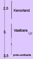 Archaean Supercontinents and continents:
Vaalbara is Earth's theorized first supercontinent, which, according to radiometric data, existed by 3.3 billion years ago (3.3 Ga) and possibly even as far back as 3.6 Ga. Geochronological and palaeomagnetic evidence suggests Valbaara began to break up ~2.8 Ga.
Ur was the first known continent, which probably formed 3 billion years ago in the early Archean Eon.
By about 2.7 Ga, Neoarchean sanukitoid cratons plus new continental crust accreted to form another of Earth's earliest supercontinents, Kenorland.
Two contrasting mechanisms have been proposed for Archean tectonics: “vertical tectonism” and “horizontal tectonism”. Vertical tectonism is attributed to density inversions inherent between denser volcanic sequences (greenstones) and underlying less dense sialic material (granitoids), which result in the buoyant rising of granitoids (diapirism) and sinking of greenstones (sagduction). Horizontal tectonism in the Archean is assumed to be similar (though probably not identical) to present-day plate tectonics, so is characterized by regional scale horizontal motion (drift) and resulting interactions of plates or microplates. Vertical tectonism can lead to local horizontal movement, and horizontal tectonism commonly results in vertical movement, as in collisional zones. However, regional scale horizontal displacements and regional scale strike-slip faults (or shear zones) cannot be explained by vertical tectonism and most likely results from horizontal tectonism. Vertical and horizontal tectonism were not necessarily mutually exclusive.
While Archean geologists now accept that processes similar to present-day plate tectonics existed in some form in the Archean, particularly in the Neoarchean, studies continue to document evidence for vertical tectonism. Recognition of synchronous vertical and horizontal tectonism proves challenging because it is often difficult to differentiate structures formed by synchronous processes from those formed by one of the two processes followed by the other. It has been suggested that the granite-greenstone patterns in the Dharwar craton in India resulted from the interplay of diapirism and bulk horizontal inhomogeneous contraction. It has also been suggested that the kinematics of a high strain zone in the northwestern Superior craton resulted from synchronous horizontal and vertical tectonism. [Lin]
◙ subduction zone magmas ◙

The Eon was formerly called the Archaeozoic, and is subdivided into Eoarchean (3.8-3.6 Ga), Paleoarchean (3.6-3.2 Ga), Mesoarchean (3.2-2.8 Ga), and Neoarchean (2.8-2.5 Ga) Eras or into early (to 3.3Ga), middle (to 2.9 Ga), and late Archaean.
Life arose about 4 billion years ago, at the close of the Hadean Eon, and Cyanobacteria comprise the earliest known microfossils. The Cyanobacteria built large stromatolite reefs and dominated life for more than 2 billion years (~3.5 Ga to ~1 Ga). The atmosphere remained reducing for much of the Achaean, though Cyanobacteria began to generate oxygen after approximately 2.8 to 2.7 Ga.
Earth's heat flux during the Archaean was much higher than current levels: early in the Archaean the flux was almost triple current levels, while heat flows fell to twice current levels by the end of the Archaean. As a result of the high heat flow, the Earth had numerous hot spots, very active volcanoes, and rift valleys. Earth continued to experience bombardment by extrasolar debris plus the late heavy bombardment until 3.5 Ga. The majority of Archean rocks still in existence are crystalline cratonic remnants, which include unusual lavas (e.g., komatiite), intrusive igneous rocks such as great melt sheets, and voluminous plutonic masses of granite, diorite, ultramafic to mafic layered intrusions, anorthosites and monzonites known as sanukitoids.
Scientists continue to actively debate the contribution of plate tectonic activity in the formation of Archaean crustal configurations. Large continents did not form until late in the Archean, and the felsic protocontinents probably formed at hotspots over mantle plumes rather than at subduction zones. Protocontinents probably resulted from:
● igneous differentiation of mafic rocks to produce intermediate and felsic rocks
● mafic magma melting of more felsic rocks
● granitization of intermediate rocks
● partial melting of mafic rock
● metamorphic alteration of felsic sedimentary rocks.
Much continental material may have been lost if rocks were not sufficiently buoyant or were consumed at energetic subduction zones.[2]
The oldest rocks so far discovered on Earth are:
1) Jack Hills, Western Australia, a 4.4 Ga detrital zircon (sample W74) in the Jack Hills metaconglomerate, Eranondoo Hill. More at Earliest Piece of Earth [news article]
2) The Acasta Gneisses near Canada’s Great Slave Lake (4.03 Ga)
3) The Isua Supracrustal rocks of West Greenland (3.7 to 3.8 Ga)
4) Northern Michigan (3.5-3.7 Ga)
5) Swaziland (3.4-3.5 Ga)
Archaean Supercontinents and continents:Vaalbara is Earth's theorized first supercontinent, which, according to radiometric data, existed by 3.3 billion years ago (3.3 Ga) and possibly even as far back as 3.6 Ga. Geochronological and palaeomagnetic evidence suggests Valbaara began to break up ~2.8 Ga.
Ur was the first known continent, which probably formed 3 billion years ago in the early Archean Eon.
By about 2.7 Ga, Neoarchean sanukitoid cratons plus new continental crust accreted to form another of Earth's earliest supercontinents, Kenorland.
Two contrasting mechanisms have been proposed for Archean tectonics: “vertical tectonism” and “horizontal tectonism”. Vertical tectonism is attributed to density inversions inherent between denser volcanic sequences (greenstones) and underlying less dense sialic material (granitoids), which result in the buoyant rising of granitoids (diapirism) and sinking of greenstones (sagduction). Horizontal tectonism in the Archean is assumed to be similar (though probably not identical) to present-day plate tectonics, so is characterized by regional scale horizontal motion (drift) and resulting interactions of plates or microplates. Vertical tectonism can lead to local horizontal movement, and horizontal tectonism commonly results in vertical movement, as in collisional zones. However, regional scale horizontal displacements and regional scale strike-slip faults (or shear zones) cannot be explained by vertical tectonism and most likely results from horizontal tectonism. Vertical and horizontal tectonism were not necessarily mutually exclusive.
While Archean geologists now accept that processes similar to present-day plate tectonics existed in some form in the Archean, particularly in the Neoarchean, studies continue to document evidence for vertical tectonism. Recognition of synchronous vertical and horizontal tectonism proves challenging because it is often difficult to differentiate structures formed by synchronous processes from those formed by one of the two processes followed by the other. It has been suggested that the granite-greenstone patterns in the Dharwar craton in India resulted from the interplay of diapirism and bulk horizontal inhomogeneous contraction. It has also been suggested that the kinematics of a high strain zone in the northwestern Superior craton resulted from synchronous horizontal and vertical tectonism. [Lin]
◙ subduction zone magmas ◙
Labels: Archean Eon, greenstones, Kenorland, late heavy bombardment, plate tectonics, tectonisms, Vaalbara supercontinent
| 0 Guide-Glossary


