Paleogeology

Paleogeology, Paleoclimate, in relation to Evolution of Life on Earth

Archaean

The Archaean, or Archean Eon extends from 3.8 billion years ago until 2.5 billion years ago.

The Eon was formerly called the Archaeozoic, and is subdivided into Eoarchean (3.8-3.6 Ga), Paleoarchean (3.6-3.2 Ga), Mesoarchean (3.2-2.8 Ga), and Neoarchean (2.8-2.5 Ga) Eras or into early (to 3.3Ga), middle (to 2.9 Ga), and late Archaean.

Life arose about 4 billion years ago, at the close of the Hadean Eon, and Cyanobacteria comprise the earliest known microfossils. The Cyanobacteria built large stromatolite reefs and dominated life for more than 2 billion years (~3.5 Ga to ~1 Ga). The atmosphere remained reducing for much of the Achaean, though Cyanobacteria began to generate oxygen after approximately 2.8 to 2.7 Ga.

Earth's heat flux during the Archaean was much higher than current levels: early in the Archaean the flux was almost triple current levels, while heat flows fell to twice current levels by the end of the Archaean. As a result of the high heat flow, the Earth had numerous hot spots, very active volcanoes, and rift valleys. Earth continued to experience bombardment by extrasolar debris plus the late heavy bombardment until 3.5 Ga. The majority of Archean rocks still in existence are crystalline cratonic remnants, which include unusual lavas (e.g., komatiite), intrusive igneous rocks such as great melt sheets, and voluminous plutonic masses of granite, diorite, ultramafic to mafic layered intrusions, anorthosites and monzonites known as sanukitoids.

Scientists continue to actively debate the contribution of plate tectonic activity in the formation of Archaean crustal configurations. Large continents did not form until late in the Archean, and the felsic protocontinents probably formed at hotspots over mantle plumes rather than at subduction zones. Protocontinents probably resulted from:
● igneous differentiation of mafic rocks to produce intermediate and felsic rocks
● mafic magma melting of more felsic rocks
● granitization of intermediate rocks
● partial melting of mafic rock
● metamorphic alteration of felsic sedimentary rocks.
Much continental material may have been lost if rocks were not sufficiently buoyant or were consumed at energetic subduction zones.[2]

The oldest rocks so far discovered on Earth are:
1) Jack Hills, Western Australia, a 4.4 Ga detrital zircon (sample W74) in the Jack Hills metaconglomerate, Eranondoo Hill. More at Earliest Piece of Earth [news article]
2) The Acasta Gneisses near Canada’s Great Slave Lake (4.03 Ga)
3) The Isua Supracrustal rocks of West Greenland (3.7 to 3.8 Ga)
4) Northern Michigan (3.5-3.7 Ga)
5) Swaziland (3.4-3.5 Ga)
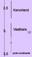
approximate ages of earliest continent (Ur) and supercontinents (Vaalbara, Kenorland)Archaean Supercontinents and continents:
Vaalbara is Earth's theorized first supercontinent, which, according to radiometric data, existed by 3.3 billion years ago (3.3 Ga) and possibly even as far back as 3.6 Ga. Geochronological and palaeomagnetic evidence suggests Valbaara began to break up ~2.8 Ga.

Ur was the first known continent, which probably formed 3 billion years ago in the early Archean Eon.

By about 2.7 Ga, Neoarchean sanukitoid cratons plus new continental crust accreted to form another of Earth's earliest supercontinents, Kenorland.

Two contrasting mechanisms have been proposed for Archean tectonics: “vertical tectonism” and “horizontal tectonism”. Vertical tectonism is attributed to density inversions inherent between denser volcanic sequences (greenstones) and underlying less dense sialic material (granitoids), which result in the buoyant rising of granitoids (diapirism) and sinking of greenstones (sagduction). Horizontal tectonism in the Archean is assumed to be similar (though probably not identical) to present-day plate tectonics, so is characterized by regional scale horizontal motion (drift) and resulting interactions of plates or microplates. Vertical tectonism can lead to local horizontal movement, and horizontal tectonism commonly results in vertical movement, as in collisional zones. However, regional scale horizontal displacements and regional scale strike-slip faults (or shear zones) cannot be explained by vertical tectonism and most likely results from horizontal tectonism. Vertical and horizontal tectonism were not necessarily mutually exclusive.

While Archean geologists now accept that processes similar to present-day plate tectonics existed in some form in the Archean, particularly in the Neoarchean, studies continue to document evidence for vertical tectonism. Recognition of synchronous vertical and horizontal tectonism proves challenging because it is often difficult to differentiate structures formed by synchronous processes from those formed by one of the two processes followed by the other. It has been suggested that the granite-greenstone patterns in the Dharwar craton in India resulted from the interplay of diapirism and bulk horizontal inhomogeneous contraction. It has also been suggested that the kinematics of a high strain zone in the northwestern Superior craton resulted from synchronous horizontal and vertical tectonism. [Lin]

◙ subduction zone magmas ◙

Labels: , , , , , ,

| 0 Guide-Glossary

regional metamorphism

mineralogical metamorphic facies along trajectories of contact and regional metamorphic temperature-pressure conditions; c=contact, a=Abukama or Buchan, b=Barrovian, s=Sanbagawa, f=Franciscan; click on image to toggle to description of metamorphic facies Regional metamorphism involves large volumes of rock subjected to heat and intense compression during tectonic events such as subduction and orogeny.

Four mineral assemblage series are recognized as resulting from temperature-pressure environments in regional metamorphism: Buchan, Barrovian, Sanbagawa, and Franciscan.

(image at left – click image to toggle mineralogical metamorphic facies –
(di = diagenetic alteration)
(h = hydrothermal metamorphism)
(c = contact metamorphism [VLPHT])
regional metamorphism:
a = Abukama or Buchan Facies Series [LPHT];
b = Barrovian Facies Series [MPHT];
S = Sanbagawa Facies Series [HPMT];
F = Franciscan Facies Series [HPLT].

The arrows trace conditions at : 'c' = contact aureoles around plutonic intrusions; a = island arcs, oceanic ridges, contact aureoles; b = continental orogenic belts; s = accretion zones; f = subduction zones.)

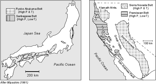
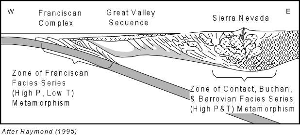
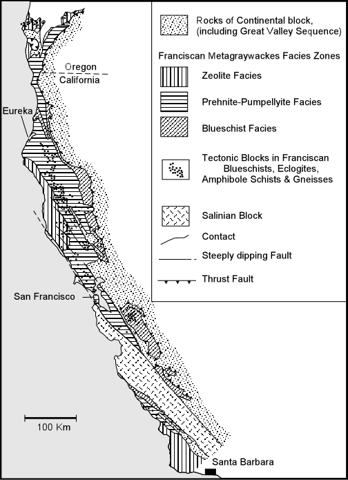
In Paired Metamorphic Belts, circumpacific belts of oceanic-side belts of high pressure/low temperature metamorphism are found associated with continent-side belts of high pressure/high temperature metamorphism. Two examples of paired metamorphic belts are seen in the Sanbagawa Belt/Ryoke-Abukuma Belt of Japan and in the Franciscan complex/Klamath Mts.-Sierra Nevada roof pendants of California. Other paired metamorphic belts are seen in New Zealand, Indonesia, Washington State, Chile, Jamaica, the Alps, and the northern coast of South America.

Most areas with paired metamorphic belts show evidence of convergent plate subduction associated with low geothermal gradients that generated the oceanic-side high pressure/low temperature metamorphism. Evidence of many such belts has probably been lost because the hydrous minerals of blueschist facies metamorphism are overprinted by facies resulting from normal geothermal gradients. Overprinting occurs when circulating fluids convert blueschist minerals to greenschist and amphibolite facies mineral assemblages.

Continental-side high pressure/high temperature belts form beneath the island arc or continental margin volcanic arc. These regions are, during emplacement of the arc, subject to higher than normal geothermal gradients, producing Buchan and Barrovian Facies Series metamorphic Rocks. These belts of high T/high P metamorphism can be subequently uplifted and exposed at the surface by emplacement of batholiths and isostatic adjustment.

The Japanese paired belts probably remained adjacent to one another because subduction moved farther off the coast after compressional tectonics accreted the island arc and trench complex to Japan at the end of the Mesozoic. The paired California belts are separated because the oceanic ridge was subducted, and then the margin of the Farallon plate converted from compression-subduction to a transform fault margin dominated by strike slip faulting. Isostatic rebound of the highly deformed Franciscan Complex has resulted in its exposure at the surface.

Regional metamorphic changes are classified according to metamorphic facies, which are recognizable terranes or zones. Metamorphic facies display an equilibrium assemblage of key minerals that were in equilibrium under specific temperature/pressure conditions throughout the orogenic terrane.

Metamorphic Facies:
low T - low P : Zeolite Facies
mod to high T - low P : Prehnite-Pumpellyite
low T - high-P : Blueschist Facies
mod to high T - mod P : Greenschist - Amphibolite - Granulite
mod to high T - mod P : Eclogite

--- ◘ Buchan or Abukama Facies Series develops at moderate pressures due to either regional heating by plutonic intrusion at shallow to moderate depths, plate collisions at convergent margins, or crustal thinning. The moderate pressures of Buchan metamorphism are lower than that of the aluminum silicate triple point, producing a critical sequence of aluminum silicates that differ from higher pressure Barrovian rocks in the Amphibolite Facies, where andalusite and cordierite appear:
kaolinite → pyrophyllite → andalusite → sillimanite

--- ◘ Barrovian Facies Series develops at higher pressures than the Buchan series, and are found in Paleozoic and some Precambrian mountain belts. Barrovian pressures are higher than that of the aluminum silicate triple point, producing the mineral series:
kaolinite → pyrophyllite → kyanite → sillimanite

--- ◘ Sanbagawa Facies Series are named for the Sanbagawa Belt, which is part of a complex that was accreted to Japan at higher temperatures than the Franciscan complex (Mesozoic), but lower temperatures than Buchan/Barrovian. The Facies sequence is:
Zeolite → Prehnite-Pumpellyite → Blueschist → Greenschist → Amphibolite Facies

--- ◘ Franciscan Facies Series develop along low geothermal gradients, and are exhibited in the mélange Cretaceous Franciscan Complex of California. [wp] Franciscan metamorphism results in a series of rocks that pass through the Facies sequence
Zeolite → Prehnite-Pumpellyite → Blueschist → Eclogite Facies.

◙ subduction zone magmas ◙

more: Contact Metamorphism Dynamic Metamorphism Regional Metamorphism and Regional Metamorphism Metamorphic Rock Identification

Labels: , , , , , , , , , , ,

subduction

diagram of Juan de Fuca plate sinking below the North America plate at the Cascadia subduction zone, courtesy USGSSubduction occurs when oceanic plates collide with continental plates, and the subducting tectonic plate slides beneath the more buoyant plate, moving down into the mantle at submarine trenches.

Subduction typically proceeds at rates of mere centimeters per year, but it is associated with intense, deep-seated seismic activity and volcanic activity (volcanic island arcs). ◙ subduction zone magmas ◙

diagram of ocean cycle with new oceanic rocks formed where mantle convection cells rise beneath mid-oceanic ridges and consumed where oceanic plates subduct at ocean trenchesWherever continental and oceanic plates collide, the denser oceanic plate subducts underneath the less dense continental plate, sinking toward the asthenosphere where the oceanic crust is consumed.

Any crustal rocks that are too buoyant to sink pile up as nappes or in orogenic zones.

Subduction zones are typically arcuate, with the convex arc directed toward the oceanic plate. More steeply inclined subduction plates create less pronounced arcs than do shallow subduction plates. Back-arc basins develop in the concave area between the subduction zone and the continent.

Model of a subduction zone with oceanic slab sinking beneath continental mantle wedge. Chains of volcanoes are associated with magmatism above the subducting slab. At subduction zones, the oceanic lithosphere, layers of marine sediments, and trapped water are recycled into the deep mantle. When the oceanic plate sinks to about 100 km in depth, peridotite is metamorphosed to eclogite, becoming denser and sinking farther into the mantle.

Diagram based on computer models of isotherms associated with an idealized subduction zone.Magmatism begins at depths of 100 km or deeper in the Wadati-Benioff zone, which is typically 100-300 km inland from the subduction trench.

Island arcs contribute about 25% of the total volume of magma produced each year on Earth (~30-35 km³), which is much less than the volume produced at mid-oceanic ridges. At the spreading centers of the mid-oceanic ridge systems, convection currents within the mantle carry basaltic magmas to the surface and regenerate oceanic crust. Island arc volcanic lavas originate in a variety of magmas.

◙ subduction zone magmas ◙

Labels: , , , , , ,

| 0 Guide-Glossary

plate tectonic theory

relationship between tectonic plates and the circum-Pacific Plate tectonic theory provides a plausible mechanism for continental drift, explaining the concentration of earthquakes and 90% of volcanoes around the 'ring of fire'
(image at right –see interactive map of This Dynamic Planet).

Tectonism involves a variety of geological phenomena and structures associated with the large-scale movement of tectonic plates:
◘ earthquakes
◘ explosion and extrusion of lava, and intrusion of magma (hypabassal, plutonic)
◘ faulting - normal, thrust, transform, listric fault – duplex structures, horse, horst & graben, klippes, nappes, shear zones, windows,
◘ folding and deformation – décollement folds,
◘ orogeny associated with continental-continental or continental-oceanic collision margins
◘ magmatism
◘ metamorphism
◘ mid-oceanic ridge spreading centers and creation of oceanic crust
◘ rifting
◘ shear zones
◘ subduction zones and submarine trenches associated with continental-oceanic collision margins causing consumption of oceanic crust; associated with accretionary prisms, mélanges.
◘ volcanic island arcs above subduction zones, and associated with generation of a variety of subduction zone magmas
◘ volcanoes

The close fit between the modern continents that were once part of a single supercontinent (Pangaea).Continental drift explains the observed close fit between coast lines at opposite sides of the Atlantic (right) as well as the paleontological observation that equivalent, contemporaneous fossilized plants and animals can be found in continents and land masses that are now separated by oceans and seas.

The ocean floor is younger than the continental crust, and is arranged in parallel "stripes" of alternating magnetization parallel to the mid-oceanic ridges.

Earth's tectonic platesConsiderable evidence supports tectonic theory:
● Earth's crust is divided into several crustal plates (left - click to enlarge image) bounded by extensional, transform, or compressional stresses
● ocean floors arise in chains of mid-oceanic ridges, and spread outward from these spreading centers, subducting beneath continental margins, where oceanic crust is melted (and subsequently regenerated at the ridges).
● sub-plate convection currents in the fluid asthenosphere circulates as convection currents underneath the solid lithosphere and move the crustal plates relative to one another (image below left)
● radioactivity deep in the Earth's mantle provides the source of heat that drives the convection currents

diagram of ocean cycle with new oceanic rocks formed where mantle convection cells rise beneath mid-oceanic ridges and consumed where oceanic plates subduct at ocean trenchesAs plates bump and grind, stresses build in the brittle lithosphere and the stored energy is ultimately released as earthquakes:
● at extensional boundaries where plates pull apart, such as spreading ridges, earthquakes are shallow, usually less than magnitude 8, and are aligned strictly along the axis of spreading.
● at transform faults where plates slide past each other, earthquakes are shallow (down to 25 km), usually smaller than magnitude 8, and exhibit strike-slip motion.
● at compressional boundaries between continental and oceanic crust, the plates collide with one another and one plate slides under the other (subduction), producing the largest earthquakes (some greater than magnitude 9) at depths that range from the very near surface to several hundred kilometers in depth (cool subducting plates can experience brittle failure as deep as 700 km)

◙ subduction zone magmas ◙

As an aid to understanding plate motion, divide the skin of an orange into square 'plates' and shift the sections relative to each other. To pull apart (extend) or push together (compress) the sections will require that edges at roughly 90 degrees to the direction of motion will slide past one another (transform).


history of plate tectonics theory : plate tectonics: mechanism :

images: This Dynamic Planet and tectonic plates courtesy of USGS

Labels: , , ,

| 0 Guide-Glossary

breccia

basaltic breccia with epidote groundmass.Breccias are clastic, sedimentary rocks comprising angular fragments from a previous rock structure that have been cemented in a matrix.
image: basalt breccia with epidote groundmass, courtesy of Siim Sepp

Classification of breccias relates to their constituents, mode of occurrence, constituent fragment size, types of clasts, and source of clasts.

Many breccias comprise consolidated talus or scree material, and are made up of accumulations of rock fragments that have fallen down steep hill slopes or cliffs. Breccia are often found above uncomformities, and so are associated with conglomerate, arkose and sandstone. (Conglomerates have rounded fragments.) Other breccias are produced by the fragmentation of rocks during faulting (tectonic or monomictic breccia), or during volcanic eruptions (eruption breccia, vent breccia), or collapses such as in karst areas, or form upon meteorite impacts (often in breccia dikes). Monomictic breccias result from rock deformation by shearing and granulation (cataclasis) in the process of tectonism or dislocation metamorphism, while impact breccias have been called "monomictic movement breccias".

[images: hand-specimens: breccia, 2, 3, 4, chert breccia; breccia in copper, 2; impact breccia; thin-sections : volcanic breccia; fault breccia in the Antietam Formation; Breccia Pernice marble, Breccia Aurora marble; formations: cliffs of volcanic breccias formed by lahars; Wawa xenolithic breccia, Wawa Heterolithic Breccia; Ries impact structure, Iggenhausen quarry, monomictic movement breccia, close-up; Azuara impact structure close-up; grit brecciation and mortar texture, Rubielos de la Cérida impact basin, and heavily brecciated and polished scour surface; strongly brecciated chert nodule, Malmian limestone, Ries impact structure; breccia dikes in Liassic limestones south of Belchite (Deutsche)]

Labels: , , , , , , ,

Acasta Gneiss Complex

Cleaned exposures of the Acasta gneisses at their discovery site. Ancient tonalites (4.03 Ga) occur on left side of the picture, and are intruded by highly deformed younger granite sheets and mafic dykes. Courtesy of Natural Resources Canada The Acasta Gneiss Complex is located in Canada's northwestern Slave Province, NWT. (more images at Geomorphology, lithology, geological history of the Slave craton.)

Dating from the Hadean at least 4.03-4.055 Ga, is Earth's oldest known crustal rock outcrop. The complex comprises mostly Gray gneiss (granodioritic gneiss), White gneiss (tonalitic to granitic gneiss), foliated granite (3.6 Ga), and many aplite and basaltic intrusions.


The gneisses are embedded in a large Mesoarchean-Hadean basement complex, which lies beneath the west-central Slave craton. This craton is a complex containing ancient collisional orogenic structures and accreted fragments. Its rock formations comprise ancient crust, juvenile arcs, mature arcs, and intervening accretionary prism material. All tectonostratigraphic units are cut by strike-slip faults and later-emplaced granitic plutons, and many strata show evidence of late extensional collapse structures. Most rock types are derived from basaltic protoliths. The basement complex is overlain by Neoarchean supracrustal sequences has plutonic intrusions dating from 2.72-2.58 Ga. (Synvolcanic plutons date from 2.72-2.67 Ga and granitic batholiths date from 2.59-2.58 Ga (late-orogenic).)

Zircon geochronology has demonstrated that at least four magmatic or metamorphic events occurred in the Acasta Gneiss Complex: 4.0~3.95 Ga, 3.75 Ga, 3.6 Ga and 3.4 Ga. Zircon from a White gneiss has revealed an age of 4,203 +/- 28Myr, implying that granitic continental crust was more widespread than previously thought, and that it was reworked into Early Archean continental crust.[r]

Weathering of the Acasta Gneisses indicates that they have been exposed by erosion for a considerable time. In other areas, quartzite, banded iron formations, and volcanic rocks sit unconformably atop the gneisses.

The Archean gneisses were united at the core of the Slave protocontinent, at least 2.9 Ga. In the nucleus of the old continent, juxtaposed rocks sometimes differ by a billion years in age, probably indicating episodic volcanic eruptions, fed by broad plumes of rock ascending periodically from the deep mantle, rather than having resulted from gradual tectonic accretion of crust at plate boundaries. Such lava flows presumably gradually built up the continental nuclei as a part of mantle mafic-ultramafic and crustal acid magmatism.

The Archean rocks subsequently experienced uplift, possibly because of a hot mantle plume. Elevation of the continent caused erosion, creating the unconformity. Two volcanic layers above the unconformity date to a little over 2.8 Ga. Subsequently the plume dissipated, and the region sank beneath an ancient ocean, accumulating sediments: quartz-rich sandstone, and then the banded iron formations (Yellowknife Supergroup). The volcanics accumulated as the Slave protocontinent was rifted apart about 2.8-2.7 Ga.

links: formation: Acasta Gneisses, 2; Acasta Gneisses; AG complex; hand-specimen: Acasta Gneiss, 1, 2, 3; Tonalite gneiss; Acasta Gneiss, 2; close-up: Acasta Gneiss; sem: Acasta Gneiss - sem; article (1999); Acasta gneiss and another old zircon; abstract, 2 pdf; article; news; Microstructure of Neoarchean zircon from the Acasta gneiss complex ... (pdf):

image of Acasta Gneisses courtesy of Natural Resources Canada (source website, Figures)

Labels: , , , , , , , , , , ,

Slave craton

northwestern Canadian Shield courtesy of USGS. Click to go to larger original. In this new map, shield rocks are subdivided into dozens of units distinguished by age, lithology and originThe Slave craton is a complex containing ancient collisional orogenic structures and accreted fragments, which now sits at the northeast of the North America craton. (map, geological map, very simplified, maximum protolith age, cross-section, northern Slave mafic intrusions).

(The Slave Province is "A" in the image at left - magnify - legend)

(more images at  Geomorphology, lithology, geological history of the Slave craton.)

Rock formations of the Slave Craton comprise ancient crust including the Acasta Gneiss Complex (A), which contains the oldest known intact Earth rocks. The craton also contains juvenile arcs, mature arcs, and intervening accretionary prism material. All tectonostratigraphic units are cut by strike-slip faults and later-emplaced granitic plutons, and many strata show evidence of late extensional collapse structures.

The Slave craton is a mere fragment of ancient crust, surrounded by Paleoproterozoic rifted margins. Cratons such as the Slave are remnants that preserve parts of the much larger, ancient pre-tectonic and tectonic systems in which they were generated. The Slave craton originated from the break-up of a much larger late Archean landmass and preserves a complex and spatially heterogeneous record of crustal growth that spans nearly 1.5 billion years. (garnets in subcontinental lithospheric mantle (SCLM))

large late Archean supercontinent Kenorland (~2.7 Ga)
_____________________________↓
late Archean parental supercraton Sclavia → Slave _ + Rae (~2 Ga) → Laurentia
__________________________________________________________+
_________________________________________Baltica, Ukraine, Amazonia, Australia
_____________________________________________ and possibly Siberia, North China and Kalahari
________________________________________________↓

______________________Columbia (Nuna, Hudsonland, Hudsonia) 1.8-1.5 Ga

The original landmass could have been the speculative late Archean supercontinent Kenorland, followed by, or perhaps more likely instead, a smaller landmass referred to as the supercraton Sclavia (a late Archean supercraton of unknown size and configuration, which is considered to be parental to the Slave craton).

The Archean gneisses were united at the core of the Slave protocontinent, at least 2.9 Ga. In the nucleus of the old continent, juxtaposed rocks sometimes differ by a billion years in age, probably indicating episodic volcanic eruptions, fed by broad plumes of rock ascending periodically from the deep mantle, rather than having resulted from gradual tectonic accretion of crust at plate boundaries. Such lava flows presumably gradually built up the continental nuclei as a part of mantle mafic-ultramafic and crustal acid magmatism.

Within the later Laurentian/Nuna supercontinent, the Archean rocks subsequently experienced uplift, possibly because of a hot mantle plume. (time chart, Yellowknife domain time chart) Elevation of the continent caused erosion, creating the unconformity. Two volcanic layers above the unconformity date to a little over 2.8 Ga. Subsequently the plume dissipated, and the region sank beneath an ancient ocean, accumulating sediments: quartz-rich sandstone, and then the banded iron formations (Yellowknife Supergroup). The volcanics accumulated as the Slave protocontinent was rifted apart about 2.8-2.7 Ga. (Hadean to Mesoarchean basement of CSBC)

The Slave craton has thick sequences of tholeiitic greenstone sequence date from ~2.7 Ga, younger arc-like sequences from 2.69-2.61 Ga, and extensive turbidite sequences from about 2.68 to 2.62 Ga. Syn-orogenic conglomerates were deposited about 2.6 Ga. Some of Canada's largest volcanogenic massive sulfide (E) deposits lie in arc-like sequences formed above the attenuated basement and in progressively widening, juvenile, back-arc-like basins. (evolution of Slave craton)

Archean cratons of similar age (Zimbabwe, Wyoming) also have quartzite layers and banded iron formations lying over gneisses. Geologist, Wouter Bleeker of the Geological Survey of Canada (GSC) says, "These may be several pieces of a larger continent of which the Slave nucleus is just one remnant."

Parts of the Central Slave Basement Complex contain quartzite gneiss similar to the quartzite found in the Southern Cross Province of the Yilgarn craton.

Many geologists dispute any possibility that plate tectonics could have operate on the early Earth. The planet was much hotter 3-4 billion Ga – too hot, many believe, for formation of rigid continental plates. Further, the hot surface layer would have been too buoyant to sink in subduction zones, preventing development of plate-tectonic cycles. Eventually Earth cooled sufficiently for the crust to form rigid, less buoyant plates, so that plate tectonics evolved as the dominant geophysical force. Bleeker speculates that the breakup of the Slave nucleus some 2.8-2.7 Ga could mark the beginning of plate tectonics.

The oldest parts of the Slave province lack the long, narrow belts of accreted and deformed rocks that are key signatures of plate tectonics. Mapping of the Slave craton has even disconfirmed some supposed relics of ancient plate tectonics.

Key elements of the geology of the Slave craton are illustrated in field photographs on the Slave Craton website, refer to cross-section of the craton (legend):
A. The Acasta gneisses at their discovery site, with ancient tonalites (4.03 Ga) on left.
B. Basal quartzites of the Central Slave Cover Group overlying basement of the Central Slave Basement Complex. To right, in low foreground are low-weathering basement gneisses. The dark ridge in background has ca. 2.7 Ga basalts overlying the quartzites.
C. Syn-Kam Group quartz-porphyritic tonalite intrusion (ca. 2713 Ma), silling into the northern part of the Yellowknife greenstone belt. The large sill-like body is cut by somewhat younger mafic dykes that likely fed the upper part of the greenstone belt. Inset altered quartz-porphyritic tonalite.
D. Quartz porphyritic rhyolite breccia with carbonate matrix, typical for the uppermost part of 2690-2660 Ma felsic volcanic edifices.
E. Massive sulphide mineralization of the Sunrise deposit, associated with ca. 2670 Ma felsic volcanic rocks just below the interface with the Burwash Formation turbidites.
F. Thickly bedded sandy turbidites typical of the Burwash Formation in its type area east of Yellowknife. Oblique areal photo shows F1 syncline refolded by north-northwest trending F2 folds.
G. Silicate facies iron formation interlayered with turbiditic greywackes, George Lake, northeastern Slave. This banded iron formation hosts significant epigenetic gold mineralization.
H. Passive margin strata of the Coronation Supergroup (Epworth Group) overlying the western margin of the rifted Slave craton, structurally at the base of Wopmay orogen.
I. Dense Proterozoic mafic dyke swarms cutting extended Slave crust and its cover

Legend for Field photos accompanying cross-section:
B. Typical 2.95 Ga foliated tonalites of the Central Slave Basement Complex with transposed 2734 Ma mafic dykes.
C, D & E. Basal quartz pebble conglomerate, fuchsitic quartzite, and banded iron formation of the Central Slave Cover Group that overlies the basement complex.
F. Variolitic pillow basalts of the Kam Group, Yellowknife.
G. Syn-Kam Group K-feldspar porphyritic granodiorite pluton in basement below greenstone belts.
H. Polymict conglomerate, including 10-30 cm granitoid cobbles, which occurs locally at the base of the younger, 2.69-2.66 Ga, volcanic cycle.
I. Carbonate-cemented rhyolite breccia typical for the younger volcanic cycle.
Well-preserved sub-biotite grade turbidites in the core of the Yellowknife structural basin, showing graded bedding and load casts.
J. Aerial photo of large scale, upright, fold structures in turbidites of the Yellowknife structural basin.
K. Late-tectonic conglomerates, formation: Acasta Gneisses, 2; Acasta Gneisses; AG complex; hand-specimen: Acasta Gneiss, 2; Tonalite gneiss; Acasta Gneiss, 2; close-up: Acasta Gneiss; sem: Acasta Gneiss - sem; article (1999); Acasta gneiss and another old zircon; abstract, 2 pdf; article; news; Microstructure of Neoarchean zircon from the Acasta gneiss complex ... (pdf); websites: The Slave Craton: Geological and Metallogenic Evolution : Abstract
Introduction : Ancient Basement Complex : The Cover Sequence : Ca. 2.73-2.70 Ga Tholeiitic Volcanism : Post-2.70 Ga Volcanism : Ca. 2.68-2.66 Ga Sedimentation : Ca. 2.65-2.63 Ga Closure Of The Burwash Basin : Post-2.63 Ga Turbidites : 2.60-2.58 Ma, Final Orogenesis : Cratonization And Beyond : Summary : References : Table : Figures : Appendix

Labels: , , , , , ,

paleomagnetism

Paleomagnetism is used to determine Earth's ancient magnetic orientation and the orientation of rock bodies relative to the magnetic poles at the time of rock formation.

Paleomagnetic studies employ the phenomenon in which magnetic minerals, such as magnetite, record the Earth's magnetic field at the time of solidification of magma or lava (Curie temperature). [image computer simulation of Earth's magnetic field] This magnetic record of prior magnetic orientation is termed thermal remnant magnetism (TRM) for igneous and metamorphic rocks, and detrital (depositional) remnant magnetism (DRM) for sedimentary rocks in which individual grains of magnetic minerals align with the magnetic field during their deposition as sediments. Chemical remnant magnetism (CRM) can be detected in some rocks as magnetic grains are deposited from circulating solutions.

Paleomagnetism has been employed to:
● map sea floor spreading as basaltic oceanic crust spreads from its line of formation along mid-ocean ridges, providing strong empirical support for theories regarding plate tectonics as a mechanism for continental drift [diagram, magnetic stripes, ridges, ridges 2, ridges 3]
● map polar wandering
● determine past global positions of ancient rock formations or terranes (when combined with radiometric determination of the age of a rock formation)
● constraining possible ages for rocks and for geologic processes
● reconstructions of deformational histories of segments of the crust.

: e-Book Magnetic Domains to Geologic Terranes (pdf) : e-Book Lectures in Paleomagnetism (html or pdf) : paleomagnetism analyses USGS : The Geodynamo :

news and articles : Earth's Inconstant Magnetic Field (NASA) : Earth Magnetic Field Reversal : Earth's Magnetic Field Is Fading & Earth's Core Spins Faster Than Surface, Study Confirms & Magnetic Field Weakening in Stages, Old Ships' Logs Suggest & Why Does Earth's Magnetic Field Flip? & North Magnetic Pole Is Shifting Rapidly Toward Russia & "Magnetic Map" Found to Guide Animal Migration & Magnetic Beaks Help Birds Navigate, Study Says & Migrating Birds Reset "Compasses" at Sunset, Study Says & Bats Use Magnetic "Compasses" to Navigate, Study Says & Lobsters Navigate by Magnetism, Study Says & Space Dust Flooding Our Solar System & New Solar Telescope Would Focus on Sunspots, Storms National Geographic :

Labels: , , , , , , , , , , ,

| 0 Guide-Glossary

. . . stratifying since 10/06/06